March through Connecticut
Latest changes: 2009-07-16 - re-organize by state / 2009-11-15: rearrange text for better flow / 2013-04-23: remove pre-march items /

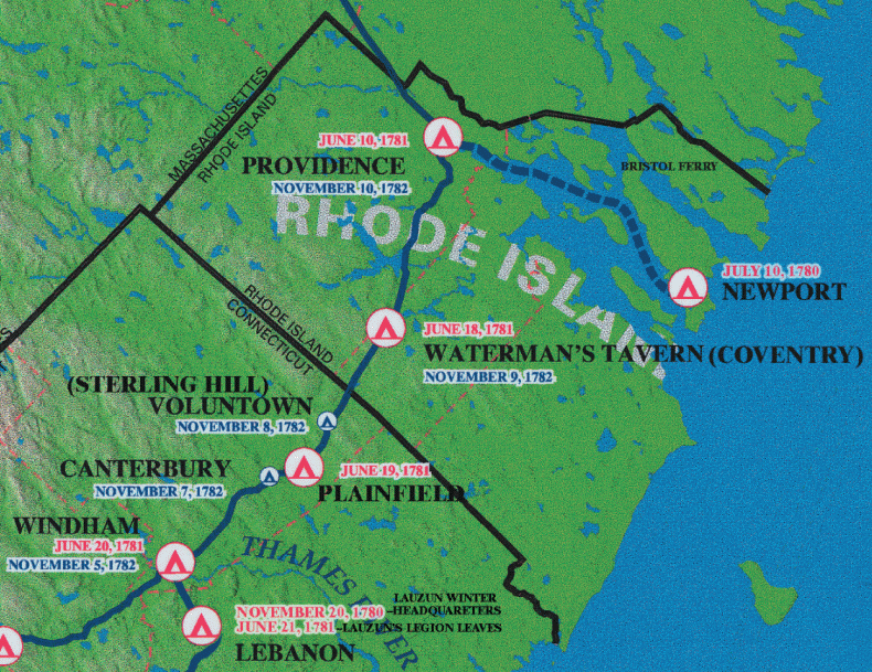
The eastern Connecticut portion of the W3R® campsite map.
NOTE: These W3R® campsite-and-trail maps were developed
during the 2000-2005 National Park Service study of significance,
feasibility, and environmental impact.
The orientation is tilted; north is about 45-degrees left of straight up.
 A Note about "Official" W3R® Routes
===== CONNECTICUT =====NOTE: The dates below overlap because they encompassthe arrival of the first unit and the departure of the last unit.
Jun 19-22 -- The route passed through Sterling and the camp was in Plainfield CT.* On this westward march the camp was opposite the present-day cemetery. Jun 20-23 -- From Plainfield, the troops passed through Canterbury and Scotland and camped in Windham.* (16 miles) The camp in Windham was about a mile west of the village. |

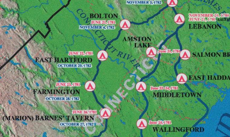
The central Connecticut portion of the W3R® campsite map
|
Jun 21-24 -- Passing through Columbia (then part of Lebanon)*,
the troops camped in Bolton (16 miles) on the east of the
church.
Jun 22-28 -- Then it was on to East Hartford, (12 miles) where the troops rested for several days. The first Roman Catholic Mass in CT may have been said by a French army chaplain in East Hartford on Sunday, 24 Jun 1781.* The camp was north of Nathaniel Warren's on Silver Lane -- so named because the French opened kegs of silver coin here to pay their men. Private and public houses on Main Street entertained the officers. It is said that they had an army hospital in the second meeting house. Lauzun's detachments likely followed the dotted lines on Rochambeau's
map #65. These begin at Middletown -- 25 miles west of their winter
quarters in Lebanon -- and show that
The Historic Route through CT after Hartford: Jun 25-28 -- The four French regiments encamped four successive days toward the south end of Farmington (10 miles via Rt 4), near the place where there is now a vacation home called "The Lodge." There is a tradition that Rochambeau and his officers stayed at the Elm Tree Inn. Jun 26-29 -- Some divisions encamped in that part of Southington (10 miles via Rt 10) now called Marion, on what was later named French Hill on the right of the Meridan road, going west. The officers were entertained at Barnes' Tavern, which was kept by Asa Barns (or Barnes), who gave a ball for them. |

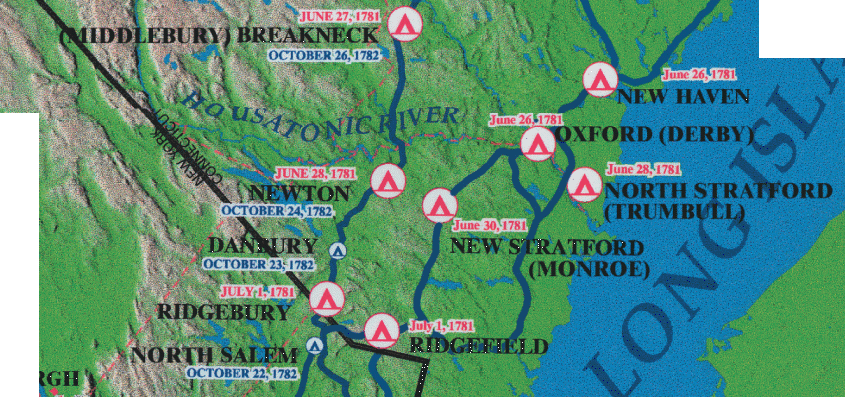
The western Connecticut portion of the W3R® campsite map.
|
Jun 27-30 -- The army then proceeded through Waterbury
Break Neck, now Middlebury (14 miles via Rt 6A)
to camp at Breakneck Hill, about a mile north of the church.
Rochambeau and his officers were entertained at Israel Bronson's tavern.
Jun 28 - July 2 -- The camp site in Newtown (14 miles va Rt 84) was south of where the middle district school now stands. At this point Washington advised Rochambeau that the French were "now in a very disaffected part of the country" and directed him to divert his march past Danbury. Jul 1-3 -- The French took the route along West Worcester Street over Hull's Hill to Ridgebury (11 miles via Rt 6). The French army arrived on Rochambeau's fifty-sixth birthday and encamped east of the Ridgebury Congregational church on the Danbury road. Washington's diary for 1781 June 28 notes he had requested Rochambeau "to file off from Ridgebury to Bedford (New York) and hasten his March...." Ref. Selig's 1999 Report, "Rochambeau in Connecticut: Tracing His Journey" for the path taken, camps, and dates. |
