Marching through New Jersey
Latest changes: 2009-07-16: regroup by state / 2010-09-15: rewrite somewhat /|
The French and Continental forces now moved along two nearly parallel routes,
rejoining at Princeton. The French marched west of the Watchung Mountains
so as to be more protected from British spies and raiding parties.
A small, eastern Continental division moved along the Hudson River, Newark Bay,
and Arthur Kill, where they built French bake ovens to deceive the British
into thinking that the French army and navy would soon be there to attack
New York City. The western Continental division moved farther inland
to serve as a screening force for the French army.
NOTE: The W3R® campsite-and-trail maps below were developed during the 2000-2005 National Park Service study of significance, feasibility, and environmental impact of the W3R®. The orientation is tilted; north is about 45-degrees left of straight up. |
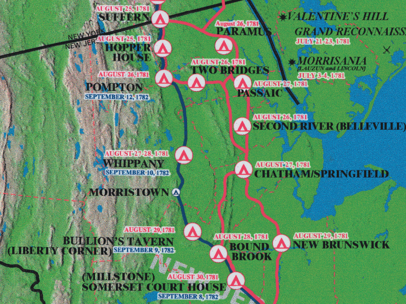
The northern New Jersey portion of the W3R® campsite map.
 A Note about "Official" W3R® Routes
===== NEW JERSEY =====W3R®-NJ member Carol W. Greene has written a well-illustrated 21-page article on the allied march through New Jersey.The allied forces now moved along several separate, nearly parallel routes, rejoining at Princeton. The French marched west of the Watchung Mountains so as to be more protected from British spies and raiding parties. One Continental division moved along the Hudson River, Newark Bay, and Arthur Kill, building French bake ovens to deceive the British into thinking that the French army and navy would soon be there to attack New York City. A second Continental division moved farther inland as a screening force for the French army. Aug 18 -- EASTERN DIVISION: The Jersey Line and Hazen's Regiment marched from Tappan (a town spreading across the line between NY and NJ) to Paramus and Belleville on the way to the heights of the Watchung Mountains between Chatham and Springfield NJ. There they built French bake ovens under the direction of French engineering officers. Aug 27 -- WESTERN DIVISION: General Lincoln, with Scammel's Light Troops (NH), the First New York Continentals, Lamb's Artillery, and the sappers and miners moved from Pompton NJ to Two Bridges and then to Chatham NJ to lead the British to believe there might be an attack on Staten Island (14 miles south via Route 45 and the Garden State Parkway). On Aug 28 they marched to New Brunswick to suggest that they might be heading for Sandy Hook to support a landing of the French fleet there. [Ref. W3R® Study for NY] Meanwhile ...Aug 26 -- The French camped at the Meeting-House in Pompton. (12 miles via Rt 202)Aug 27 -- The French camped at Whippany. (20 miles via Rts 202 and CR 511) Aug 29 -- The French camped at Bullion's Tavern -- now Liberty Corner. (4 miles via CR 511) Aug 30 -- The French camped at Sommerset Court House (now Millstone), 14 miles via Rt 202) ==> Also on this day Admiral de Grasse's fleet arrived at the Virginia Capes (off the Chesapeake Bay). |
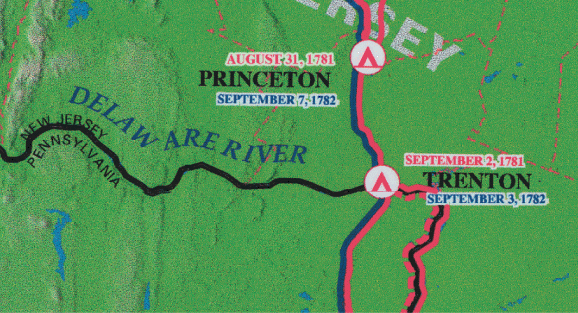
The southern New Jersey portion of the W3R® campsite map.
|
Aug 31 -- The French camped at Princeton (12 miles via Rt 206).
The Continental troops had passed through this town several days earlier
so as not to overload the campsite and provisioning capabilities of the area.
==> Also on this day French Admiral de Barras left Newport with an eight-ship squadron carrying the siege artillery and the food that would be needed during the planned siege at Yorktown. ==> Also on this day British Admiral Hood sailed from New York City with 19 warships, seeking to prevent de Barras from getting to Virginia. Sept 1 -- The French camped at Trenton (10 miles via Rt 206). Much of the Continental went south from here on row-barges with cannon and other supplies. From here all the allied forces went to Philadelphia. |
