Entering, Exploring, and Leaving New York
Latest changes: 2013-04-02: update / 2013-04-23: summarize factors to march south /
Arriving at the Allied EncampmentJul 2 -- The French army next stayed at Bedford (14 miles via Ridgebury Road south to Wallace Road, west to North Salem, and south on Rt 121). No plan of the bivouack is available. The Second Brigade skipped the Bedford camp. Lauzun's hussars (who had arrived a few days previously) joined Continental troops under Gen. Benjamin Lincoln in an attack on British posts at the northern tip of Manhattan Island. The initial stages did not go well, so the attack was aborted. Jul 3-6 -- The French troops marched 5 miles via State Rts 172 and 117 and stayed several days at New Castle (North Castle). This is now the Leonard Park - Northern Westchester Hospital area of Mount Kisco. [See The Westchester Historian, Fall 1981.] The French troops then marched 16 miles west via Rt 133 and south via Route 100 through Hawthorne to Philipsburg (now the Ardsley / Hartsdale area). [See The Westchester Historian, Fall 1981.] |
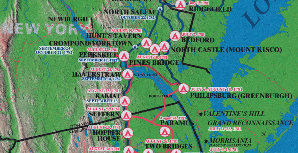
The New York portion of the W3R campsite map.
NOTE: These W3R campsite-and-trail maps were developed
during the 2000-2005 National Park Service study of significance,
feasibility, and environmental impact.
The orientation is tilted; north is about 45-degrees left of straight up.
 A Note about "Official" W3R Routes
Details of the Allied EncampmentThe layout of the allied encampment in the summer of 1781 was captured in a detailed drawing of the Dobb's Ferry area by Berthier, the principal cartographer accompanying the French Expeditionary Force. His map legend notes that there were about 4,000 Ameicans and 5,000 French troops in the camps near Dobb's Ferry from July 6 to August 19, 1781. NOTE: The settlement was incorporated as the Village of Dobbs Ferry in 1873. It is now a subdivision of the town of Greenburgh, which covers most of the area in the two maps below.Dr. Richard Borkow, historian for Dobbs Ferry, transcribed Berthier's locations of the major campsites onto a modern map of the area (see below). The base maps are © 2005 DeLorme (www.delorme.com) Street Atlas USA®
|
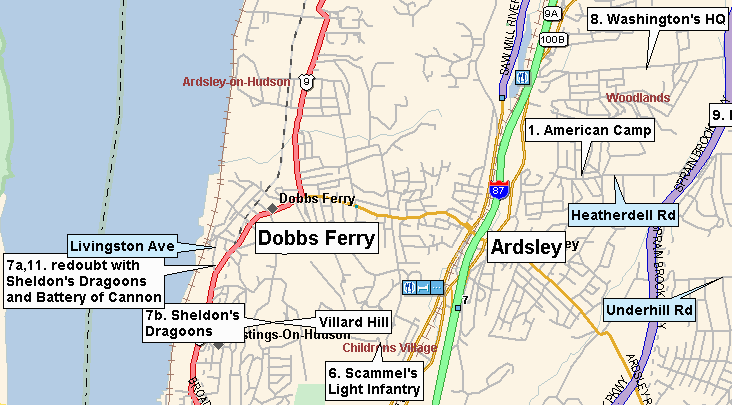
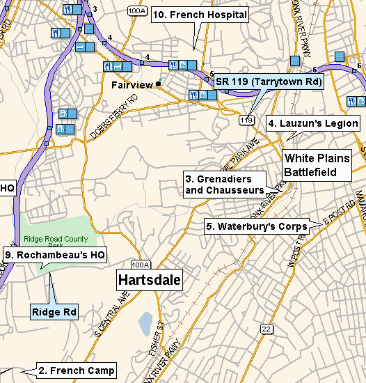
Testing the Defenses around New York CityJul 5 - Aug 19 -- The troops spent the next six weeks in several campsites around Philipsburg (now the Dobbs Ferry / Ardsley / Hartsdale / White Plains area). Rochambeau was quartered at the Odell farm, at 425 Ridge Road, Hartsdale NY. This is still standing and is used as a museum. Washington's headquarters were where the Ardsley High School now stands. Maj. Gen. Chastellux stayed at a house that is still standing on Healy Ave. South (Scarsdale NY) near the eastern border of the Sunningdale Country Club.The allies sent strong parties to probe the British lines for weakness.
The British had spent five years developing their defenses, which included
thousands of troops and a strong fleet.
It was going to be hard to dislodge them from New York City.
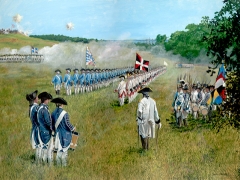
"First Amphibious Assault against the English" by David R. Wagner
(used with the artist's permission) General Clinton Waffles:
The allied commanders studied the disposition of British troops and defenses
in the New York area and considered how they might use their combined army
of 9,000 men to attack and dislodge British Gen. Clinton and his 14,000 troops
from New York City. There seemed to be no promising options. However, the
proximity of such a large enemy force led Clinton to ask Cornwallis
Shipping Gold to Finance a Global War: During this time French Admiral de Grasse was in the Caribbean, engaging the British fleet there and gathering the supplies needed for the trip north. In order to save the trouble of Spain shipping gold from South American across the ocean to Spain and then France shipping gold across the ocean to the Caribbean the French and Spanish devised an interesting scheme. The French fleet would borrow gold from Spanish merchants in Cuba to buy supplies from Spanish merchants in the Caribbean and then the French government would repay the debts by sending gold across the Pyrenees to the merchants' families in Spain. This avoided the risk that the ships carrying the gold might being captured by the British as it crossed the ocean twice -- going from France to the Caribbean to buy the goods and then going back to Spain as profit from the suppliers in the Caribbean. |
The Focus Shifts to YorktownOn Aug 14 Washington and Rochambeau received a communication from Lieutenant général des armées navales de Grasse informing them that his fleet was leaving the Caribbean Sea and would arrive off the entrance to the Chesapeake Bay in late August with 28 ships-of-the-line and 3,000 land troops. He would not come as far north as New York City, and he would leave for the West Indies by October 15 so as to avoid hurricanes and the winter storm season.Since a successful attack on New York required significant French naval support
it was clear that any plans for attacking New York must be abandoned,
but there was an excellent chance of besieging and defeating British General
Cornwallis and his 9,000 troops on the Yorktown peninsula.
However, to do this the allied troops presently north of New York City
would have to arrive at Yorktown before the British troops there were
evacuated or received reinforcements from New York.
The new objective was swiftly approved, and arrangements for feeding
and transporting the troops along that route (perhaps previously planned in case
this opportunity might arise) were set in motion.
Washington and Rochambeau sent word to Admiral de Grasse of the new plan and asked Admiral de Barras to sail from Newport to the Chesapeake Bay with the French siege artillery and the reserve provisions. Washington sent his map makers south to map out the NY to VA portion of the route. The field officers of both armies were told to prepare to break camp and move on a moment's notice. Washington split the American forces -- 2,500 Continentals (backed by thousands of local militia) would remain in New York under General Heath to keep the British from advancing up the Hudson River Valley. Only a few senior officers knew that the true objective was to be Yorktown, 450 miles to the south. It was important for the British to think that the move was a prelude to a strike on New York City so that they would concentrate their forces there. |
The New York portion of of the W3R campsite map
The Continentals March in New York East of the Hudson River
To reduce the pressure on campsites and to accomplish several different objectives
Washington split the American forces into several divisions.
General Heath and some 2,500 Continentals (backed by thousands
of local militia) would remain behind to deter the British in New York City
from raiding the surrounding area or capturing the fortified area around West Point.
Washington led the other 2,500 American troops
on a rapid march 450 miles to the south. The units traveling south were:
Aug 18 -- EASTERN DIVISION: The Jersey Line and Hazen's Regiment was ferried across the Hudson River from Dobbs Ferry to Sneeden's Landing, marching through Tappan (a town spreading across the line between NY and NJ) and on into New Jersey. Aug 19 -- WESTERN DIVISION: The remaining Continental units left their camps and assembled ("paraded" was the term used in 1781) in Dobbs Ferry, with Scammel's light infantry in the van (at the front). As they came down Ashford Ave (present-day name) and reached Broadway, Col. Scammel led the line of march to the right (away from New York City), to the surprise of the men, who were expecting a march to attack New York City. For most of these regiments this corner was the start of the march to Yorktown. They marched north along the Hudson River, crossed the Croton River at New Bridge, near the Van Cortlandt Manor House, and continued to Verplanck Point (16 miles via Routes 9 and 9a and Kings Ferry Road), where they crossed the Hudson. |
The French Troops March in New York, East of the Hudson River Rochambeau led the roughly 5,000 French troops on a parallel route farther inland. At the same time (Aug 17) Rochambeau wrote to Choisy in Newport, commanding him -- in cooperation with Adm. Barrass -- to embark all able troops (about 430 in number) and the siege cannon and to sail for Jamestown VA. The only French troops remaining in Newport were 100 invalids.Meanwhile half of the French units (Division A) returned to New Castle (Mt. Kisco)
-- 16 miles via Rts 100B, 100, and 133. The other half (Division B) marched
by way of Thornwood, Pleasantville, and Chappaqua (along the present
Saw Mill River Parkway). [See The Westchester Historian, Fall 1981.]
Aug 22 -- The two French divisions camped at King's Ferry (now Verplank) -- 14 miles via Rts 202, Furnace Dock Road, Washington Road north, and Kings Ferry Road) [See The Westchester Historian, Fall 1981.] British General Clinton was aware of the American / French troop movement but unaware of their strategic plan until early September. Even then he thought that superior British naval power could deny the American / French forces a victory at Yorktown. Aug 24 -- Haverstraw (4 miles south of Stony Point Park) via Route 9). One French brigade camped in front of the Treason House in West Haverstraw. It took six days (Aug 20-25) to ferry all the units across the Hudson River from Westchester County at Kings Ferry (Verplank, on the east side of the Hudson River) to Stony Point, on the west side. |
The March in New York West of the Hudson RiverAug 25 --#1 - General Lincoln, with Scammel's Light Troops (NH), the First New York Continentals, Lamb's Artillery, and the sappers and miners moved from Kakiat (now New Hempstead) NY to Pompton NJ #2 - The French troops encamped in New Antrim (now Suffern) NY (11 miles via Rt 202). An historical marker on Washington Ave., south of the intersection with Lafayette Ave., notes this area as "Rochambeau's Encampment 1781-1782". Rochambeau is said to have made his headquarters at John Suffern's New Antrim Tavern. [Ref. W3R Study for NY] #3 - The slower-moving American baggage train was guarded by a detachment from Rhode Island as they moved from Kakiat (now New Hempstead) NY to New Antrim (now Suffern) NY. [Ref. W3R Study for NY] ==> Also on this day a fleet of 14 warships under British Admiral Hood arrived at the mouth of the Chesapeake Bay, hoping to find and to engage the French in battle. Finding no one there, they sailed on north to New York City. |
Pearls along the Necklace -- Nearby Revolutionary-Era Sites |
