Maps of the Historic W3R® Network
General sketch of the land and water routes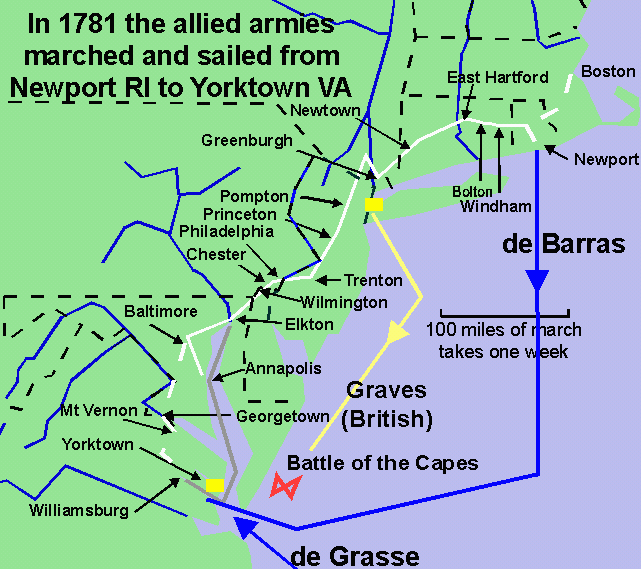
white = allied army main land route, grey = allied army bay route
blue = French navy route, yellow = British navy route,
|
A note about "official" maps
The official Washington-Rochambeau (WARO) trail as designated by the U.S. Congress in 2009 --  NPS_TO1-80,001
-- is really a corridor containing many interconnected paths.
The allied army was split into French and U.S. columns.
Each column was split into several divisions that marched
separated by one day's journey to pre-established campgrounds
spaced a day's march apart (about 14 miles). Various auxiliary units
took other routes around the main units to deliver messages between the units,
to bring in wagons of provisions for the troops and their horses and oxen,
and to provide screening and scouting forces. NPS_TO1-80,001
-- is really a corridor containing many interconnected paths.
The allied army was split into French and U.S. columns.
Each column was split into several divisions that marched
separated by one day's journey to pre-established campgrounds
spaced a day's march apart (about 14 miles). Various auxiliary units
took other routes around the main units to deliver messages between the units,
to bring in wagons of provisions for the troops and their horses and oxen,
and to provide screening and scouting forces.
Below are maps of the chain of the main campsites used by the allied armies of France and the United States during their moves south in 1781 from Newport RI, Boston MA, and near Dobbs Ferry NY to Yorktown VA. The same camps were used as the U.S. Continentals marched back north to Newburgh NY in 1781 and as the French army marched north to Boston MA in 1782. |
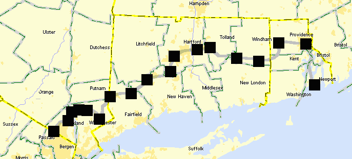
Rhode Island to New York
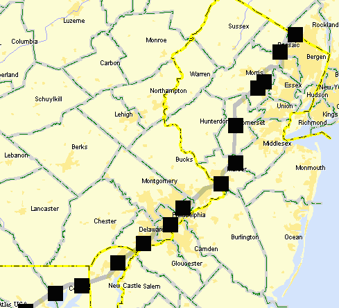
New Jersey to Delaware
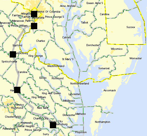
Maryland to Virginia
Maps of the Historic RouteAfter the 1781 Yorktown battle French cartographers drew a detailed map of the entire route based on contemporary field drawings and reports. This map has been digitized by the Library of Congress and is available online through the National Park Service's
website for the W3R®-NHT.
Included with the digitized map is an on-line magnifier.
In 2010 the National Park Service published a limited number of spiral-bound booklets containing nine, full-color, 6" by 9.5" maps that show enough detail to see what towns and modern roads are near the historic W3R®-NHT network of paths taken by the allied armies in 1781. To make these maps more accessible to the public we have posted them on the W3R®-US Website as 200 DPI TIFF files. You may download and print them for personal use. If your browser does not open the files download them and see if a photo viewer application (such as Windows Picture and FAX Viewer) will open them. |
The Library of Congress has put online
 the Rochambeau Map Collection
-- over a hundred maps (drawn during 1780-83) from the personal collection of Gen. Rochambeau.
Maps for the area travelled by the French Expeditionary Force are noted
below: (numbers refer to Collection order): the Rochambeau Map Collection
-- over a hundred maps (drawn during 1780-83) from the personal collection of Gen. Rochambeau.
Maps for the area travelled by the French Expeditionary Force are noted
below: (numbers refer to Collection order):
--- overview of the whole route (65), 40 maps of the campsites (67), --- MA (14), RI (38-41, 42-44), CT (7), NY (21-33), NJ (18-20), --- PA (37), DE (8), MD (8, 12, 13), VA (50-64). Rutgers University has a cartography site with a 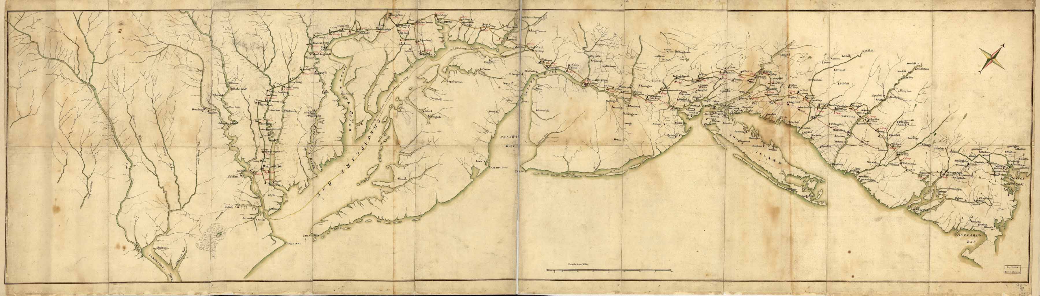 detailed sepia map of the route.
They grant permission solely to view the map image, not to download or to print it.
detailed sepia map of the route.
They grant permission solely to view the map image, not to download or to print it.
At one time the History Department of the U.S. Military Academy at West Point had posted about fifty Revolutionary War maps scanned at high-resolution (as both GIF and EPS files). for download and view at any magnification. That index was at www.dean.usma.edu/history/web03/atlases/american%20revolution/index.htm. |
|
detailed sepia map [Library of Congress]
A representation of the sea fight on the 5th of Sept. 1781
between Rear Admiral Graves and the Count de Grasse
outside the Capes of the Chesapeake Bay.
Map of the entrance of Chesapeake Bay [Library of Congress]
in early October 1781 showing the positions of the French fleet,
British vessels, and the U.S. and French land forces.
|
