Admiral D'Estaing, 1778
Admiral d'Estaing sailed from France's Mediterranean naval base at Toulon
with twelve ships-of-the-line, four frigates (a total of 958 cannon)
and transports containing several French army regiments.
The fleet was manned by 7,500 sailors and carried 2,500 marine riflemen, and 1,500 soldiers.
His mission was to help dislodge the armed forces of Great Britain from U.S. territory.
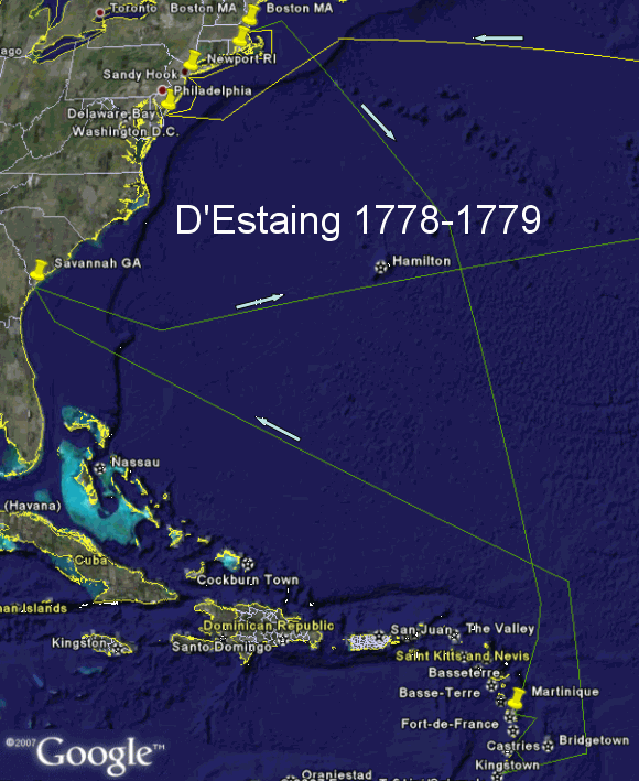
See the track by the uppermost arrow on the map at right ==>.
 Google-map of the voyage Google-map of the voyage
This displays notes for the stops and can display the map at higher magnification.
News of their coming led the British to abandon Philadelphia.
On June 28 as the British marched back to New York the U.S. Continentals
attacked the rear guard of the British column near Monmouth NJ.
1778 Jul 06: After nearly three months at sea French Admiral D'Estaing's fleet
reached the mouth of the Delaware Bay and restocked his ships with food and water.
Since the British were no longer in Philadelphia he sailed on to New York City.
1778 Jul 11-27: French Admiral D'Estaing explored the British fortifications around New York City
but was unsuccessful in developing a feasible plan for a successful attack,
so he sailed on to Newport RI.
1778 Jul 29-Aug 31: Bad weather and poor coordination of forces doomed D'Estaing's
participation in an allied attack on the British garrison at Newport.
His fleet sailed to Boston for repairs.
For more see details
1778 Nov 04: D'Estaing departed from Boston for Martinique (in the West Indies),
arriving there on Dec 09. See the track by the next-uppermost arrow on the map.
1778 Dec 13: The British captured St. Lucia (in the West Indies).
|
Admiral D'Estaing, 1779
1779 Jan: The British occupied St. Martin ( in the West Indies),
which had been under the control of the Dutch and French.
The British also occupied St. Barthèlèmy (West Indies)
1779 Feb 24: The French re-captured St. Martin (West Indies) from the British.
1779 Feb 28: The French re-captured St. St. Barthèlèmy (West Indies) from the British.
1779 Jun 18: The French captured St. Vincent (Virgin Islands).
1779 Jul 4: The French captured Grenada (West Indies).
On Jul 25 D'Estaing departed for Savannah GA.
See the track by the lowest arrow on the map.
1779 Sep 23-Oct 20: D'Estaing's forces joined the American army
in an unsuccessful siege of British-held Savannah GA.
For more see details
1779 Nov: D'Estaing's fleet departed for France, arriving in December..
See the track by the next-lowest arrow on the map.
|
|
FLY THE ROUTE!
The above graphic is a snapshot of a Google Earth view generated by a KML
file that can be used to follow the path of D'Estaing's fleet and zoom in on the cities.
You may get the free Google Earth viewer from
earth.google.com. It is a large file.
Once you have the Google Earth viewer installed on your computer you can display the
1778-79 voyage of d'Estaing's fleet in by clicking on this link ==>
destaing.kml. This Web window will remain open,
so you can refer back here for instructions. If there is a large Google search window
at the bottom of the Google Earth window you may close that search window.
The folder title "D'Estaing's Exp Force" should be highlighted now,
so you can start the flying tour by clicking on the ">" arrow
just under "D'Estaing's Exp Force", at the bottom of the "Places" list of files.
This tour pauses five seconds at each port of call.
After the tour you may
-- click the + to the left of "D'Estaing's Exp Force" globe to display the folder
-- click the + to the left of "D'Estaing's Exp Force" to expand the folder
-- double-click on the name to the right of a pushpin to fly there and display the description.
|
|
