Marching and Ship Transport through Virginia
Latest changes: 2009-07-16 - re-organize by state /
|
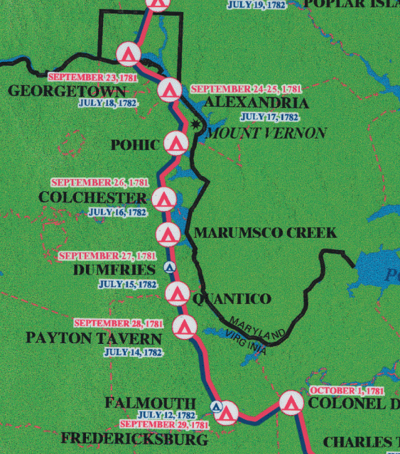
The northern VA portion of the W3R® campsite map developed for the National Park Service
2000-2005 study of significance, feasibility and environmental impact. |
In Virginia the route has been marked with small green highway
markers with white lettering. This was described in a brochure
produced by the Expédition Particuliére (Durf McJoynt,
PO Box 137, Mt Vernon VA, 1981). In what follows, SR is State Route
and SnR is Secondary Route.
 A Note about "Official" W3R® Routes A Note about "Official" W3R® Routes
1781 Sept 10 and 11 - For two days the allied generals -- Washington and Rochambeau -- and their senior staff members enjoyed the amenities of Mount Vernon and consulted about very serious military matters. The allied operation was at the most precarious phases of an exceptionally high risk operation as the allied land and naval forces flowed in from distant geographic locations to focus on the British at Yorktown. The timely successes of three separate strategic movements were essential for victory, but they were beyond the immediate control of Washington or Rochambeau. Two Days at Mount Vernon
[Expédition Particuliére] provides the full story.
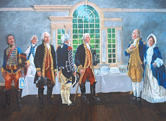
"First Official Use of Mt. Vernon's Dining Room" by David R. Wagner
(used with the artist's permission) Sept 12 -- The officers followed SR 235 to US 1 to SnR 611 to US 1 again, to Woodbridge, Dumfries, Stafford Court House, and Falmouth. The officers spent the night in Fredericksburg. George Washington had spent his boyhood here, and his brother had built the Rising Sun Tavern here in 1760. |
|
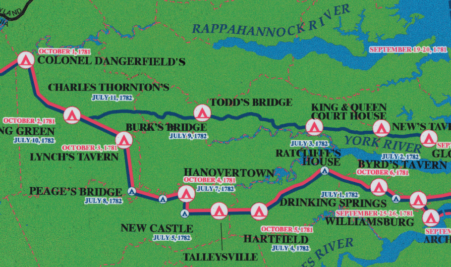
The middle VA portion of the W3R® Campsite map
developed for the National Park Service
2000-2005 study of significance, feasibility and environmental impact. |
|
Sept 13 -- SR 2 to New Post, Wideawake, Villboro to SnR 626 to
SnR 609 to SR 2 again. Then SnR 631 to SR 2 north of Bowling Green
to SnR 695 south of Bowling Green to SR 2 again to SnD 627 to SnR 654
west to SnR 656, then SnR 648 south to Lorne where they moved onto
SnR 649 to SnR 600 to SnR602 to SnR 651 and back and forth across
SR 2 several times to stay at the Hanover Court House Inn,
travelling some 53 miles for the day.
Sept 14 -- SnR 605 to SnR 604 to SnR 606 east of Studley to Old Church and Tunstall then SnR 609 to SR 249 to SR 30 to US 60 past Toana, Norge, and Lightfoot to arrive at Williamsburg after travelling 47 miles. |
|
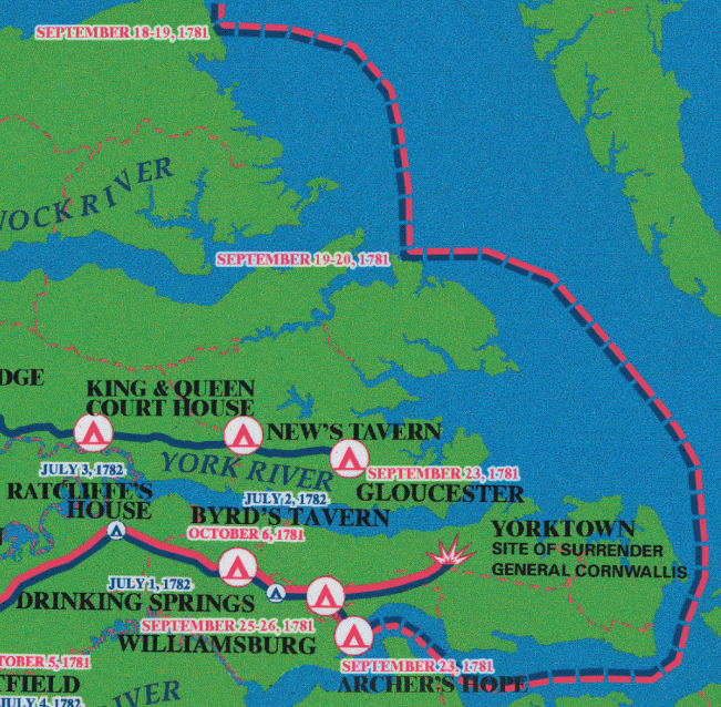
The eastern VA portion of the W3R® Campsite map
developed for the National Park Service
2000-2005 study of significance, feasibility and environmental impact. |
|
De Grasse could not easily leave his cabin on the Ville de Paris because he had
become very feeble due to asthma. Bouillé, governor of French Leeward Islands,
stated that he almost did not recognize de Grasse when he arrived from Europe
in the spring of 1781. This is why de Grasse requested Adm. de Barras to represent
him at Cornwallis' surrender.
On three occasions De Grasse asked the French Court (Marquis de Castries,
the Navy Minister) to be replaced:
(1) before Yorktown, (2) before the capture of St Kitts, and
(3) before his last combat at the Saint, but this was not accepted by the Minister.
[Ref.: note from Jacques de Trentinian]
Sept 17 - General Washington met with Admiral* de Grasse on the French flagship, the Ville de Paris at Hampton Roads [the Lynnhaven Bay area at the mouth of the James River]. To better match the British cavalry under Tarleton at Gloucester the allied commanders sent a dispatch to the hussars (Group C2) directing them to leave the baggage train (which could be guarded by local militia now) and instead travel to Gloucester VA to secure the northern side of the James River so that the Britih forces could not break out of the siege toward that direction.. A more detailed and documented description of their route is available at Expédition Particuliére * = de Grasse' rank in 1781 was Lieutenant général des armées navales, which in 2013 roughly corresponds to Admiral in the U.S. Navy. Sept 21 -- The French baggage train, accompanied by Lauzun's cavalry, crossed the Potomac River at Georgetown (then a part of Maryland, now a part of the District of Columbia) [This site has been marked by the SAR.] About this time 200 cavalry in the Compaigne General under Baron Ludwig von Closen & Cromot du Bourg crossed the Lower Potomac River at "Laidlers Ferry" in Morgantown MD (near US Route 301). Sept 24 -- The troop transports from Annapolis began to arrive at Archer's Hope with the 7,500 infantry. They joined the French expeditionary regiments delivered Sept 2 (see above) by de Grasse. ==> Also on this day the baggage train was loading large amounts of hay at Col. Daingerfield's plantation, Belvidere, east of SR 2 and north of SR 17, south of the Rappahannock River near Fredericksburg. The hussars (Group C2) received the dispatch with new orders and set out (via Todds Bridge) for Gloucester. The wagons (Group C3) continued on their original route and would not all arrive at Williamsburg until Oct 4. Sept 28 - At 5 AM the grand army -- some 16,000 troops -- marched out of Williamsburg and set up camp outside the British defenses at Yorktown. Final preparations for a siege had to hurry forward, since food supplies were scarce. This area was not accustomed to raising or importing food for the 9,000 French and 11,000 U.S. soldiers in Yorktown. The troops surrounding Yorktown could eat up all of the colony's food reserves in a few weeks. Virginia Governor Thomas Jefferson struggled to obtain the required food, often giving his personal promissary notes to farmers to pay for supplies. Oct 7 - The French wagon train -- the last unit to arrive -- delivered its goods to the allied camp. On that same day American troops began digging trenches to encircle the British camp. The last major military action of the Revolutionary War that would take place in the United States was about to begin. |
| March in MD | Top of Page |
