Take an Auto Tour along the W3R®
Latest changes:2018-08-30 convert NY, NJ guides to PDF
2019-09-07 complete MD, DC, VA routes and guides
2020-06-19 add Yorktown tours
City and Site ToursThe GPS-enabled "Yorktown Tour Guide" app (created by the American Battlefield Trust) is available as a free download from App Store, Google Play, or Web App. Download it to your cell phone or tablet for use when touring Yorktown VA. The app contains photos of the structures, directions to get from one site to the next, and both text and audio descriptions of the sites as they relate to the 1781 siege and victory at Yorktown.Three Tours at Your Fingertips: The app takes users on three distinct tours:
Free audio tour guides: The W3R®-US has prepared several audio tours of sections of the W3R®-NHT. These are available (free) through  IZI Travel.
Search that site for "Rochambeau" to get a list of the tours available.
The tour package includes both graphics and audio related to the history.
You may watch and listen to these on your computer. IZI Travel.
Search that site for "Rochambeau" to get a list of the tours available.
The tour package includes both graphics and audio related to the history.
You may watch and listen to these on your computer.
If you wish to listen to them on your smartphone while touring the trail (and not connected to the internet) you must download and install the IZI Travel app from the appropriate app store: Windows 10 Apple, Mac Open the app, search for "Rochambeau" to see the available tours, and click on the one you want. You may play the tour as a streaming file (not stored on your smartphone) or click on the download icon to store it on your smartphone. Each tour takes about 100 MB of space. You can drive or walk the tour using he IZI Travel app without requiring an internet connection. |
Auto Tours within the States A Note about "Official" W3R® Routes A Note about "Official" W3R® Routes
Print It -- Read It -- Drive It : Guides for auto tours of the W3R®: MA | RI | CT | NY | NJ | PA | DE | MD | DC | VA We thank the Delaware Department of Transportation for developing a website with an interactive map covering the W3R®-NHT through Delaware.
The format is a bit different than that used for the new main
W3R®-US website.
We are exploring the use of KML files in Google Maps. Read about it and try it! Hikes in RI | GuidedTours | NPS Passport stamps | Details (huge) |
|
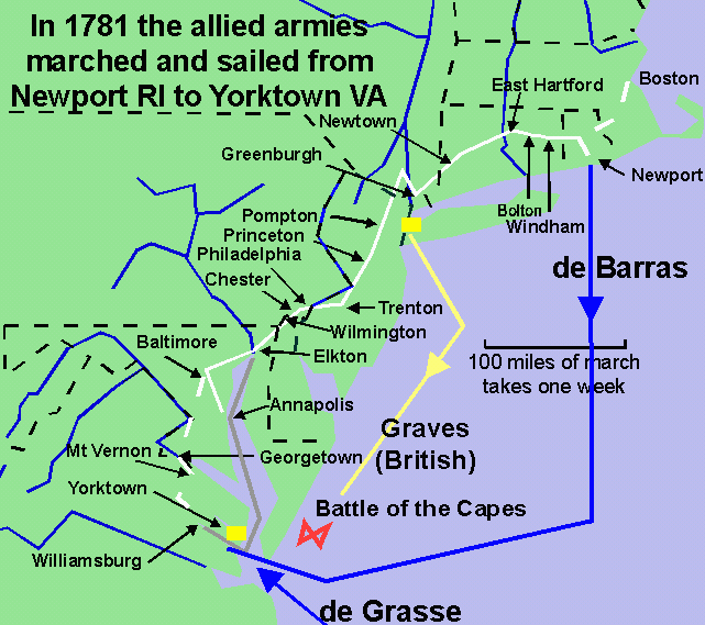
Click on the white line in the map below to get information about the trail in that state.
Legend for the Map Below: WHITE = main army land route, BLACK =state boundaries, GREY = sailing route BLUE = major rivers or French fleet route; YELLOW = British fleet route |
NPS Passport Stamps for Sites along the W3R® NPS Passport stamps [Wikipedia]
for the W3R®-NHT are now available at
|
Commercial Guided ToursNOTE: Reference to any commercial service is for the purposes of identification and user convenience and is not an endorsement or approval by the W3R®-US of that service. The tour companies listed here are not connected with the W3R®-US, have not paid to have the notes and links posted here, do not provide funding to the W3R®-US, and have not been fully evaluated by the W3R®-US. This section has information about guided tours that visit sites and present narratives related to the U.S.-French alliance of 1778-1783. Bicycle tours of the W3R®-NHT,
a project of the
Bicycle Tour Company
|
