Signage along the W3R®-NHT
Latest changes: / 2014-05-28 consolidated state activities here for NY, CT
Guidebooks / Interpretive and Route Signs along the W3R®-NHT W3R® marker list.
If can click a link near the top of that page you can see a GoogleMap™
of the W3R® markers in their collection. W3R® marker list.
If can click a link near the top of that page you can see a GoogleMap™
of the W3R® markers in their collection.
NOTE: This list does not yet include all the signs (see below) that we have installed. Waymarking.com is an excellent resource for finding specific interpretive signs
among the thousands that have been put up over the past century.
You may search that site for signs with specific content, for example
Varied Resources to Help Tourists and StudentsMaps, Brochures and Guidebooks: The National Park Service has a published
a color brochure covering the history and route of the W3R®.
Connecticut has published a guidebook
and a detailed 24-panel tourism map of the W3R®.
Route Markers: RI, DE, and VA have installed numerous W3R® route markers. Interpretive Signs: Most states along the trail have these. You can make a fine family trip by driving to see nearby interpretive signs and the parks or historic buildings associated with them. Interactive Computer Kiosk: The Pencader Area Historical Museum in Delaware has an interactive computer kiosk, with information on the whole trail and extra material for its Delaware portion. State chapters of the W3R®-US have the primary responsibility for initiating signage projects with their affiliates. The status of W3R® signage in the various states is summarized in the state blocks below (in order from north to south). |
MassachusettsNo new markers have been placed here. There are several W3R®-related markers that should be noted here. We are awaiting volunteer help to find and describe them. |
Rhode IslandIn 2006 May the state placed about 140 route markers along the W3R® in Rhode Island.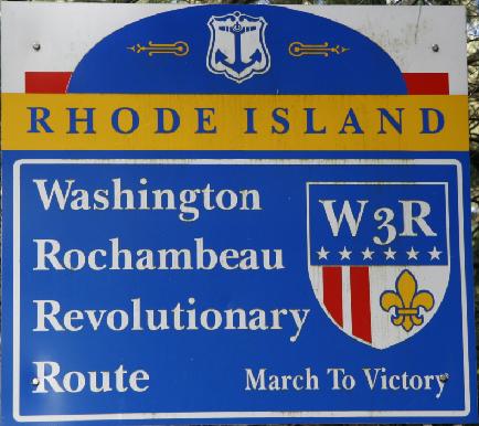
In 2010 the highway department placed a W3R® gateway sign on Rt 14 at the border with CT. Several interpretive signs are planned for Newport and Providence. |
ConnecticutIn 2005 and 2006 the W3R®-CT installed 12 interpretive signs along the W3R® in that state. The design and construction of the signs were funded by a private donation.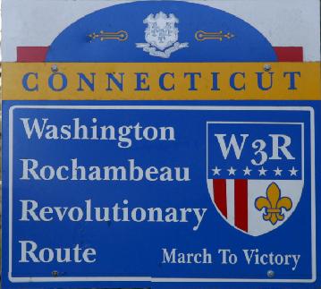
In 2010 the highway department placed a W3R® gateway sign on Rt 14 at the border with RI. |
New YorkIn 2006 local historical societies placed 45 interpretive signs at sites where officers and troops stayed along the W3R®In 2013 the National Park Service, the Hudson River Valley National Heritage Area, and the Hudson River Valley Greenway made plans for further development of 15 of these sites. See signs in NY for map and list. |
New JerseyIn 2006 the town of Mahwah placed about 20 route markers (in three sizes) along the W3R® through that town. |
PennsylvaniaSeveral Interpretive signs are being developed. Requests for route markers will be made now that the trail has been designated a National Historic Trail.-- In 2009 the town of Chester placed vertical banners along the route. See photo-report -- In 2011 the W3R®-PA placed several banners along the Shuylkiill River where the 1781 French camp at Philadelphia was located. See photo-report |
Delaware-- In 2005 the W3R®-DE placed an interpretive sign (next to the Grand Opera House in Wilmington, Delaware) to commemorate the stay of Lauzun's Legion (French Army) of 550 soldiers, who were posted in nearby buildings for a five-month period in 1782-3. This was funded jointly by the Delaware Societies of the SAR and the DAR. The April 22 dedication ceremony was a highlight of the 2005 annual meeting of the W3R®-US, held in WIlmington.The interpretive sign [PDF file] -- In 2006 October the Delaware Department of Transportation placed about 40 route markers along the W3R®. -- In 2009 the Pencader Heritage Association placed a sign (designed in part by the W3R®-DE) outside its museum on Old Baltimore Pike (part of the W3R® through Delaware) honoring Continental Army General Lafayette. See photo-report -- In 2010 the Pencader Heritage Association
installed the interactive computer kiosk that had been developed
by the W3R®-DE with a grant from the Delaware Department of Tourism.
Photo |
MarylandThe W3R®-MD has designed an interpretive sign for installation in Annapolis in 2010 and has requested MD state route markers along the W3R®-NHT now that the trail has been designated a National Historic Trail. The W3R®-MD hopes to replace the interpretive sign that was placed by the SAR at Camden Yards in Baltimore during the Bicentennial of the American Revolution (1976-1983). |
District of ColumbiaThere is a plan to replace the interpretive sign that once stood at the site where the allied baggage train forded the Potomac River in Georgetown. |
VirginiaThe DAR has updated and replaced several interpretive signs that were originally created and placed at Mt. Vernon and Yorktown during the Bicentennial of the American Revolution (1976-1983): 2003 Oct 29 - fund-raising starts
Mt. Vernon on 2005 May 14.
Mt Vernon sign [a PDF file]
The DAR replaced a sign at Yorktown on 2006 Oct 19 [no photos yet]. |
